


LE TOUR DU PARC PENCADENIC

rousseau.mich
User
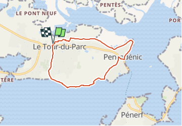

Length
6.3 km

Max alt
14 m

Uphill gradient
32 m
Km-Effort
6.7 km

Min alt
-1 m

Downhill gradient
30 m
Boucle
Yes
Creation date :
2025-04-13 12:53:03.11
Updated on :
2025-04-13 12:53:54.174
1h31
Difficulty : Easy

FREE GPS app for hiking
 SityTrail
IGN / Geographical institutes
SityTrail Plus
The world is yours!
About
Trail On foot of 6.3 km to be discovered at Brittany, Morbihan, Le Tour-du-Parc. This trail is proposed by rousseau.mich.
Positioning
Country:
France
Region :
Brittany
Department/Province :
Morbihan
Municipality :
Le Tour-du-Parc
Location:
Unknown
Start:(Dec)
Start:(UTM)
526472 ; 5263723 (30T) N.
Comments